Menu
Request Booking

Paznauner Höhenweg – 9 Stages, 11.000 meter, 120 Kilometer

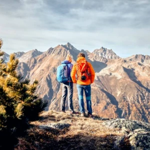
The Paznaun High Trail is the ideal way to get to know the Paznaun region from its most beautiful side. Over nine stages, the high-altitude trail takes you to the most impressive spots in Paznaun. Past glistening mountain lakes and along idyllic alpine meadows - with the most beautiful mountain peaks always in view. A variety of different landscapes await you on the Paznaun High Trail. Steep paths, leisurely trails, lush alpine meadows and stony sections await you along the nine stages of the trail. You can enjoy the lush flora and alpine barrenness to the full. So let's get going!

The Tiroler Höhenweg is one of the most beautiful hiking trails to be found anywhere in Europe. This claim is confirmed by the fantastic landscape and the breathtaking views that you can enjoy again and again along the route. The tour is strenuous, but definitely worth every step! It is particularly recommended to hike the high trail in the warmer months, as you can then enjoy the wonderful natural surroundings to the full.

Kontaktinformationen

The individual stages at a glance

  • Stage 1 – The Beginner Stage

    The first stage leads from See – a neighbouring town of Ischgl – to the Ascher hut at 2,256 metres above sea level. You’ll see: this moderately difficult stage is the perfect prelude to the rest of the exciting Paznaun High Route. 

    Details:

    • walking time: 5.5 hours, distance: 12.5 kilometes, level of difficulty: moderate
    • difference in altitude – ascent: 1,480 metres, descent: 270 metres 
    • stop options: Ascher hut 
    • parking options: parking ground See cable cars 
    • Download: GPX Track Paznaun High Route – stage 1 

    Route: from See to the Ascher hut 

    • Starting point: parish church in See at 1,050 metres above sea level 
    • an asphalt trail leads to the eastern hamlet Oberfrödenegg at 1,270 metres above sea level (walking time: approx. 35 minutes) 
    • past the “Giggler Tobel” path and the former snack station “Almstüberl” to the fork in the route in Giggl 
    • following the signposts “Ascherhütte”, continue to the next fork in the route and select the upper trail
    • Start of the actual route: at the little chapel, continue to the wildly romantic – and unfortunately, abandoned – Giggler Alm hut 
    • walk towards the valley through romantic larch forests and across the Gigglbach brook 
    • following the signposted paths, you’ll reach the first stage goal after about 1.25 hours: the Ascher hut at 2,256 metres above sea level. 

    Lookout and photo points: 

    After you’ve crossed the Gigglbach brook, a challenging fixed-rope section rewards you with an impressive view of the entire lower part of the Paznaun. Tip: Take a break and take a couple souvenir pictures! This spot is perfect to take a breather, take in the mountain views and forget the world around you for a few minutes. 

  • Stage 2 – All the way through the Untertal valley

    Crystal clear mountain lakes, incredible scenic views of the mountains, pristine nature … Stage 2 of the Paznaun High Route is a true gem and leads you all the way through the Untertal valley. 

    Details: 

    • walking time: 8 hours, distance: 21.5 kilometres, level of difficulty: moderate 
    • difference in altitude – ascent: 920 metres, descent: 2,000 metres
    • options for a stop: Ascher hut, Gamperthun Alm hut
    • parking options: parking ground Kappl cable cars, park deck Kappl village
    • Download: GPX Track Paznaun High Route – stage 2

    Route: from the Ascher hut to Kappl 

    • Start: Ascher hut at 1,256 metres above sea level 
    • along the hut trail towards the mountain station of the 6-people chairlift See, follow the signposted trail to the fork in the route and select the lower one and continue on to the Furglertal valley and follow the signpost towards “Masnerjoch” 
    • above the Berglis Wand wall, you’ll reach the Bergli via a high route 
    • follow the signpost “Restaurant” down into the valley until the next fork in the route 
    • up the mountain and past the Fisser hunting lodge, you’ll reach the Stial-Alm hut at 2,050 metres above sea level 
    • after the descent into the Flathtal valley, the last challenging ascent of the tour awaits: towards the Gamperthun Alm hut at 2,070 metres above sea level 
    • past the mountain chapel Gamperthun (along a pasture path), you get to the Grübeletal valley and the “outer” Alm hut 
    • after 500 metres on foot down into the valley, there is a forest road and, later, a panorama trail, return to the forest trail at the signposted fork in the route, then past the Rotweg chapel and, finally, you’ll reach your stage goal: Kappl

    Lookout and photo points:

    • Once you reach the Stial-Alm at 2,050 metres above sea level, you should go on the lookout for the Haflinger horses – these pretty horses with fox-coloured fur and blonde manes and tails spend the summer in the mountains. 
    • At the “outer” Alm hut, there is a fork in the road towards Lake Grübelsee. You can reach this crystal-clear mountain lake within 30 minutes on foot. At the lake, there’s also an “inner” Alm hut which is perfect for a little break. 
    • While hiking along the panorama trail, time and again, you’ll have an amazing view of the town of Kappl with its plentiful hamlets. 
  • Stage 3 – The smuggler's stage

    There are two variations of the smuggler’s stage: a moderately difficult and a difficult one – without any trails. No matter which one you choose: this hike leads you from Austria to Switzerland and back. And it’s incredibly beautiful. 

    Details: 

    • walking time: 9.5 hours, distance: 21 kilometres, level of difficulty: moderate / or: difficult 
    • difference in altitude – ascent: 2,000 metres, descent: 1,800 metres 
    • options for a stop: Visnitz Alm 
    • parking options: parking ground See and Kappl cable cars, Silvretta parking ground Ischgl
    • Download: GPX Track Paznaun High Route – stage 3 

    Route: from Kappl to Ischgl 

    • Starting point: from Kappl, follow the signpost “Samnaun” 
    • after 1.5 hours, you’ll reach the Visnitz Alm at 2,250 metres above sea level and, after another 40 minutes or so, you’ll encounter a footpath – the actual smuggler’s route 
    • at the end of the Visnitz valley, you’ll walk towards Samnaun past the lower and upper Zollhütte (toll hut)
    • a narrow and steep path leads up to 2,694 metres above sea level to the eastern Visnitzjoch – from there, you’ll head over to Switzerland above the Alp Bella at 2,400 metres above sea level 
    • continue below the Muttersattel, past the lakes towards the "äußer" Viderjoch
    • alternative route for experienced alpinists: from the eastern Visnitzjoch, across the ridge along the state line towards the western Visnitzjoch – duration: approx. 45 minutes; over steep and rocky hillsides without trails and about 200 metres of boulders down to the lakes and the signposted path towards the "äußer" Viderjoch 2,732 metres above sea level. Note: The alternative route can only be hiked on good weather days and by experienced mountaineers! The descent towards the lakes doesn’t have any trails! 
    • once you’ve reached the "äußer Viderjoch" via the upper Vellilalpe at 2,061 metres above sea level, follow the signposted trail down into the valley towards Ischgl
    • tip for sore muscles: from the "äußer" Viderjoch, you can reach the Flimjochbahn in a few minutes – from there, you can float down to Ischgl with the Fimbabahn and Silvrettabahn cable cars …

    Lookout and photo points along the smuggler’s stage 

    The Visnitz valley is wildly romantic and deserted – take a breather and enjoy nature to the fullest. 

  • Stage 4 – Obertal Dream Stage

    The name says it all when it comes to this stage – the “dream stage”: it’s truly a dream hike through the idyllic mountain and meadow landscape. Stunning panoramic views and lots of other highlights reward every hiker for the challenging ascent from the first second onwards. 

    Details:

    • walking time: 7.5 hours, distance: 16 kilometres, level of difficulty: moderate
    • difference in altitude – ascent: 1,800 metres, descent: 1,600 metres
    • options for a stop: Larein Alpe hut
    • parking options: Silvretta parking ground
    • Download: GPX Track Paznaun High Route – stage 4

    Route: from Ischgl to Galtür

    • starting point of this hike is the parish church Ischgl – from there, you’ll hike up towards the intermediate station 
    • past the suspension bridge “Kitzloch” further on to the Rauhen Kopf at 2,478 metres above sea level; you’ll get there after a 2.5-hour-long, exhausting ascent through the forest and past the hunting lodge at the Tschamatschkopf at 2,066 metres above sea level 
    • towards the valley along the ridge, there is another descent to the Außerbergli at 2,080 metres above sea level and the Innerbergli at 2,066 metres above sea level 
    • from the Innerbergli, there is a one-hour descent to the Larein Alpe at 1,860 metres above sea level 
    • continue on to the Stafali pond and along the Galtür high route towards Galtür

    Lookout and photo points:

    • once you’ve reached the Rauhen Kopf – Ischgl’s backyard mountain – it’s time to relax: enjoy nature, the successful hike and the impressive view! During good weather conditions, you can see all the way from the Bielerhöhe to Imst in Tyrol. 
    • From Innerbergli, you should definitely take a little detour to Lake Berglisee. You’ll reach this idyllic mountain lake with deep blue water within 15 minutes. 
  • Stage 5 – the Relaxation Stage

    The stage from Galtür to the Friedrichshafener hut is possibly the most relaxing and leisurely stage of the Paznaun High Route. Hikers are delighted: that way, they’ll have even more time to enjoy nature to the fullest and to get to know – and love – the Paznaun!

    Details:

    • walking time: 3.5 hours, distance: 7 kilometres, level of difficulty: moderate 
    • difference in altitude – ascent: 850 metres, descent: 250 metres
    • options for a stop: Friedrichshafener hut 
    • parking options: parking ground sports and cultural centre Galtür 
    • Download: GPX Track Paznaun High Route – stage 5 

    Route: from Galtür to the Friedrichshafener hut 

    • starting point is the village centre Galtür from where the hike leads towards the district of Außertschaffein at 1,560 metres above sea level and along a signposted trail to the Friedrichshafener hut 
    • at the flood and avalanche protection passage, you’ll continue on the road to the Friedrichshafener hut at 2.138 metres above sea level 

    Lookout points and interesting facts: 

    • The hike from Galtür to the Friedrichshafener hut was set up by the Tyrolean flood and avalanche protection bureau.
    • You’ll find respective information boards along the trail – on them, you can read interesting facts about vegetation, forestry and control structures as flood and avalanche protection measures. 
    • When you’ve reached the information board passage, you’re right in the middle of the Verwall mountain range. Have a look at the opposite side of the valley! That’s where you’ll see the Samnaun mountain range where the previous hikes have already taken you. 
  • Stage 6 – Ludwig Dürr-Way

    You’d better have plenty of strength and some well-trained muscles! The “Ludwig-Dürr-Weg” packs quite a punch! But if you don’t, there’s also a second – moderately difficult – alternative route. 

    Details:

    • walking time: 6.5 hours / alternative: 7.5 hours
    • distance: 10 kilometres / alternative: 13 kilometres 
    • difference in altitude – ascent: 1,150 metres / alternative: 1,480 metres 
    • difference in altitude – descent: 950 metres / alternative: 1,240 metres 
    • level of difficulty: difficult / alternative: moderately difficult
    • options for a stop: Friedrichshafener hut, Darmstädter hut 
    • Download: GPX Track Paznaun High Route – stage 6


    Route: from the Friedrichshafener to the Darmstädter hut 

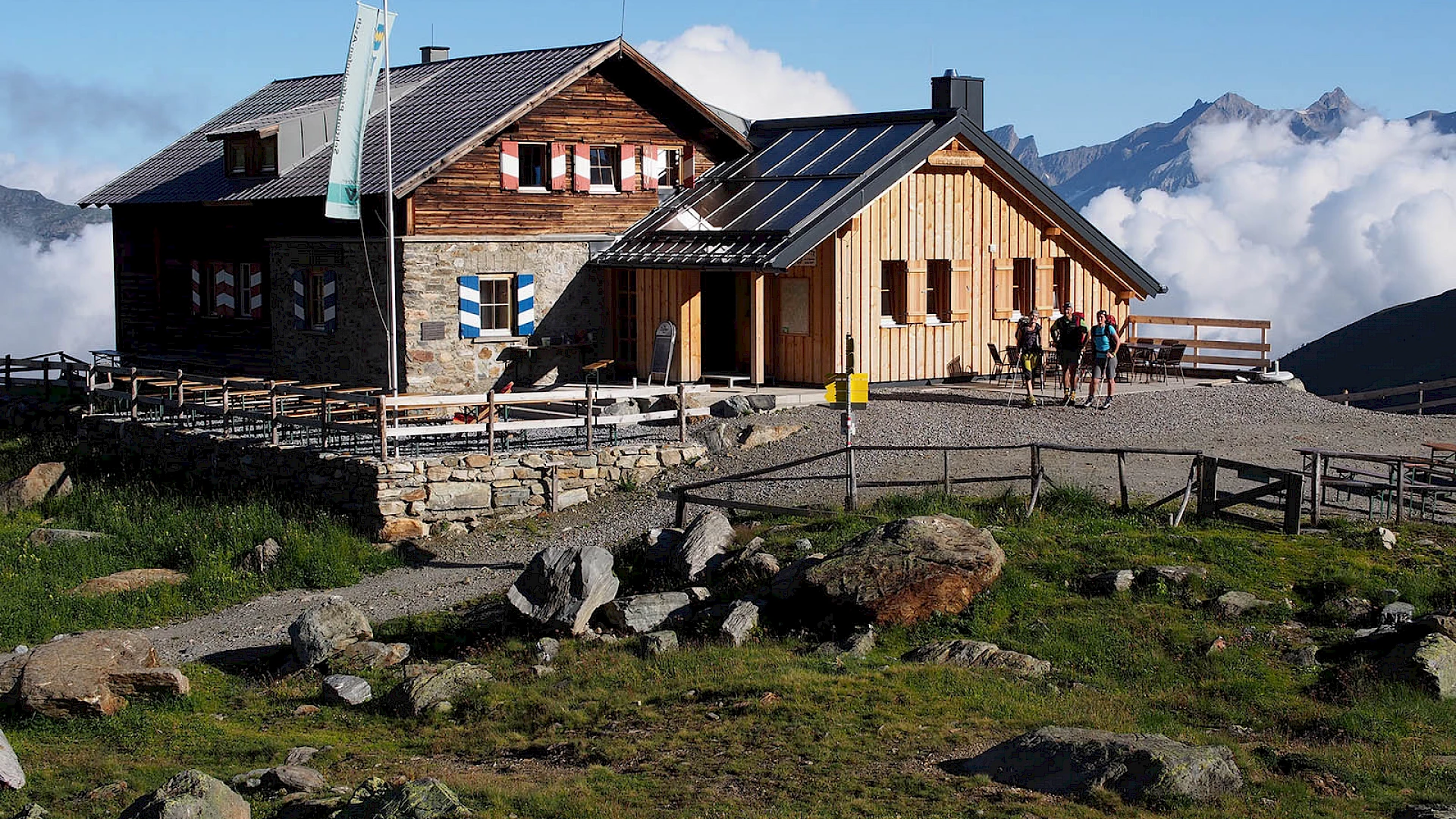
    Starting point is the Friedrichshafener hut at 2,138 metres above sea level. The first version of the route leads you along the famous (and notorious) “Ludwig-Dürr-Weg”. It’s by far the most challenging trail of the entire Paznaun High Route. The second version is a lot more moderate in terms of difficulty and perfect for less experienced alpinists. 

    • VERSION 1 – via the “Ludwig-Dürr-Weg” to the Darmstädter hut:
       
    1. the Matnaljoch or the Dürrschartl at 2,670 metres above sea level is about 1.5 hours walking time away from the Friedrichshafener hut
    2. you’ll continue along the signposted trail and across the Schönpleisübergang to the Zwischengrat ridge at 2,770 metres above sea level on a route filled with snow fields and steep passages all the way to the Rautejoch at 2,750 metres above sea level 
    3. once the Darmstädter hut is already within sight, it’ll take you about 1.5 hours to get there – across the foothills of the Küchelferner
    4. Note: for this version, experienced alpinists need ice picks and crampons – even in late summer! Alpine experience and good knowledge of the mountains are obligatory! 
       
    • VERSION 2 – via the Schafbicheljoch to the Darmstädter hut: 
       
    1. from the Friedrichshafener hut, you’ll hike to the Schafbicheljoch at 2,636 metres above sea level
    2. descent via the Fasultal valley to the wood bridge of the Fasulbach brook at 1,750 metres above sea level 
    3. at the Apothekerweg (pharmacist’s trail), the hike leads across the Kuchenjoch at 2,384 metres above sea level to the Darmstädter hut. 

    Interesting facts:

    The “Ludwig-Dürr-Weg” is the most difficult high-alpine part of the Paznaun High Route and is only recommended for experienced alpinists! Please check the current weather conditions ahead of the hike!

  • Stage 7 – Advokatenweg und der Hoppy Seyler Trail

    More than half of the Paznaun High Route lies behind you! And still, there’s one route after the next! More unforgettable views, new experiences and a feeling of utmost freedom up in the mountains await you at stage 7 of this long-distance hiking route at the Tyrolean Paznaun! 

    Details:

    • walking time: 5.5 hours, distance: 9 kilometres, level of difficulty: difficult
    • difference in altitude – ascent: 1,000 metres
    • difference in altitude – descent: 1,100 metres 
    • options for a stop: Darmstädter hut, Niederelbe hut 
    • Download: GPX Track Paznaun High Route – stage 7

    Route: from the Darmstädter hut to the Niederelbe hut 

    • starting point is the Darmstädter hut at 2,384 metres above sea level 
    • then you’ll continue over boulders and gravel along the “Advokatenweg” trail through the posterior Kartell 
    • a two-hours-long steep descent leads you up to the Schneidjöchl between the Saumspitz and Seeköpfen at 2,842 metres above sea level
    • from there, the “Hoppe-Seyler-Weg” leads you into the Vergrößkar and on a narrow path further on to a mountain shelter – the Kieler Wetterhütte hut
    • an alpine descent – with fixed-rope passages – lead you down to the Niederelbe hut 

    Lookout points and interesting facts:

    • The Kieler Wetterhütte hut is a mountain shelter and has two sleeping places in case of an emergency.
    • Especially the last part of the hike leads through high-alpine terrain. Falling rocks should be expected! So please watch the hillsides above you and wear a helmet just in case. 
  • Stage 8 – The Kieler and the Rifflerweg

    In good spirits, we continue on to stage 8 of the Paznaun High Route! This stage leads past idyllic mountain lakes, across lush green mountain pastures and through rocky terrain. 

    Details:

    • walking time: 4.5 hours, distance: 9 kilometres, level of difficulty: moderate
    • difference in altitude – ascent: 700 metres, descent: 600 metres 
    • options for a stop: Niederelbe hut, Edmund Graf hut 
    • Download: GPX Track Paznaun High Route – stage 8

    Route: from the Niederelbe hut to the Edmund Graf hut 

    • starting point is the Niederelbe hut at 2,300 metres above sea level 
    • a pleasurable hike out of the valley along the Kieler-Weg awaits you
    • pass the ski resort Kappl – then, a steep and exhausting ascent follows up to the Schmalzgrubenscharte at 2,697 metres above sea level 
    • continue along the Riffler-Weg towards the Schmalzgrubenseen lakes 
    • last ascent is to the Edmund Graf hut at 2,408 metres above sea level
       

    Tip: If your strength and the weather allow it, you should climb the Hoher Riffler (3,168 metres above sea level) in the afternoon! Walking time is about 2.5 hours from the Edmund Graf hut to the summit. 

    Lookout points and interesting facts:

    Take a little breather at the Schmalzgrubenseen lakes and let the surrounding landscape and the crystal-clear water enchant you! 

  • Stage 9 – The Kingsstage

    The last stage of the Paznaun High Route is about to commence. It has all the reason to be called the “king’s stage”. It offers hikers of the Paznaun High Route a last chance at impressive views of the already-covered distance and the past stages – and it’s the culmination of an adventure-filled long-distance hike.

    Details: 

    • walking time: 9.5 hours, distance: 22 kilometres, level of difficulty: moderate 
    • difference in altitude – ascent: 1,150 metres, descent: 2,600 metres
    • options for a stop: Edmund Graf hut 
    • parking options: parking ground See cable cars
    • Download: GPX Track Paznaun High Route – stage 9

    Route: from the Edmund Graf hut to See 

    • starting point is the Edmund Graf hut – from there, an hour-long descent leads to the Kappler Joch at 2,672 metres above sea level 
    • then, you’ll continue on to the Durrichalpe and past the Blankaseen lakes – some of the most beautiful scenic places at the Paznaun 
    • finally, the last few ascents of the Paznaun High Route are ahead of you: via the Amweg to Spidur at 2,210 metres above sea level, then the Niederjöchl at 2,346 metres above sea level and the Peziner Spitze at 2,550 metres above sea level 
    • from the Perziner Spitze, you can start your descent via the Alpe Kleingfall to Falgeneier and further on to See

    Lookout points and interesting facts:

    • The Blankaseen lakes are amongst the most beautiful places at the Paznaun. They lie embedded within a harsh mountain massif and their blue-green water evokes an unbelievable feeling of freedom amongst hikers. Look around and enjoy – that’s the motto! 
    • The Peziner Spitze at 2,550 metres above sea level is one of the most beautiful mountain ridges of the Alps. From there, you’ll have a 360-degree view of all cardinal directions and you get to look back on the stages of the Paznaun High Route that you have already completed.